language

North-west corner of Clyde and Adair Streets – former police complex

De l'audiowalk Historic Tour of Linton: Walk 2 | LINTON

Historic Tour of Linton: Walk 2
33 Stations
38:56 min Audio
directions_walk favorite 1
North-west corner of Clyde and Adair Streets – former police complex

This site contained the original police house (a six-roomed weatherboard with front and side verandas on 2 acres of land), a police station with gaol cell at the rear, the paddock where police horses were stabled, and further along Adair St, a brick Court House built in 1862.

Court sat here every Thursday with local JPs presiding. During World War 2 the Court House was used as an aeroplane spotting station by local volunteers. The building was demolished in 1946 and the bricks from it were later used in the construction of Sovereign Hill in Ballarat.

The original police house was sold for removal in the 1960s. Two other police houses have since replaced it, the most recent being built in 2014. The police station was relocated to Sussex St in 2006 (see Walk No 1), and the excess land has been sold.

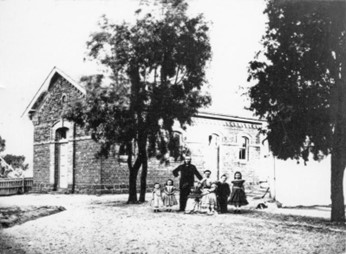
The photo on your screen is of Linton Court House with Constable Thomas Kennedy and family, taken in 1869 or 1870.



Écoute la visite audio maintenant, de préférence en grand écran.

Ou utilise l'application pour écouter l'audiowalk sur place :

1
Installer l'application guidemate Disponible dans l'App-Store & le Play-Store.
2
Ouvrir l'audioguide dans l'application Autres visites disponibles via une application.
3
Commencer sur place ! Audio, carte & infos - également hors ligne.

Autres étapes de cette visite audio :

Introduction (1:58 min) • Clyde Street - site of Grenville Standard newspaper office and RSL Hall (1:30 min) • 12 Grantley St – Todd family’s house (0:30 min) • 10 Grantley St – former Methodist Church (0:58 min) • 8 Grantley St – former Methodist Church manse (0:26 min) • 4 Grantley St – former St Paul’s Church of England Parish Hall (0:59 min) • St Paul’s Church of England (2:14 min) • 16 Linton-Piggoreet Road – former Shire Engineer’s House (0:34 min) • Linton-Naringhil Rd – former Church of England Vicarage (0:58 min) • In between Glenelg Highway, Mannibadar Road, and Nelson Road – former Presbyterian Church (1:17 min) • 3017 Glenelg Highway (Cnr Linton-Naringhil Rd) – site of the Victoria Hotel (1:59 min) • 97 Sussex St – former Wishart’s house and blacksmiths, now The Forge (0:58 min) • Corner of Glenelg Highway/Sussex St – site of Dawe family shop and residence (0:59 min) • 94 Sussex St – former private hospital run by Phemie Wishart (0:17 min) • 92 Sussex St – former home of Martin (Mick) and Joyce Chung (0:46 min) • Edinburgh Reserve – site of the Edinburgh mine (1:49 min) • Next door to 18 Cumberland Street - site of former Glamorgan mine (0:28 min) • Site of the Barry family’s house and the Misses Barry’s Private Music School (next to former Catholic presbytery) (1:34 min) • 25 Cumberland St – former house of Kennedy family, 'Kinkora' (0:41 min) • St Peter’s Catholic Church (1:35 min) • Corner Cumberland and Clyde Streets, opposite the church – former Catholic Presbytery (0:35 min) • North-East corner Clyde and Adair Streets – former house of Shire of Grenville Crown Land inspectors (0:24 min) • Site of Lands Department offices (0:21 min) • Linton Bowls Club (0:28 min) • Linton State School No. 880 (1:51 min) • Grant St – site of old cottage (1:27 min) • Corner of Grant Street and Sussex Street (Glenelg Highway) - site of Dr Donaldson’s House (1:20 min) • Site of Edward Hartley's Chemist Shop (0:23 min) • Recreation Reserve (1:47 min) • Ballarat to Skipton Rail Trail – former Ballarat to Linton railway line (2:43 min) • Denison St - Avenue of Honour (2:52 min) • Conclusion (0:54 min)


Tours

Recherche Utiliser un bon d'achat Visites audio par ville Marches audio indépendantes du lieu Blog

Compte

S'inscrire

Aide

FAQ Guide du guide

À propos de nous

Prix et conditions Programme de partenariat Matériel de presse Technologie Conditions générales de vente Protection des données Mentions légales